2011-12-14

The Messinian Salinity Crisis (3/3) - mechanisms for forming a huge salt pan

[1st chapter of this post (1/3)]
[2nd chapter of this post (2/3)]
[Spanish version of this post]
  ResearchBlogging.org
In two previous parts of this post I tried to summarize the evolution of the Messinian salinity crisis, the period of widespread salt precipitation in the Mediterranean. This 3rd part focuses on our own research, aiming at finding a mechanism to explain the long first evaporitic phase (Stage 1). 
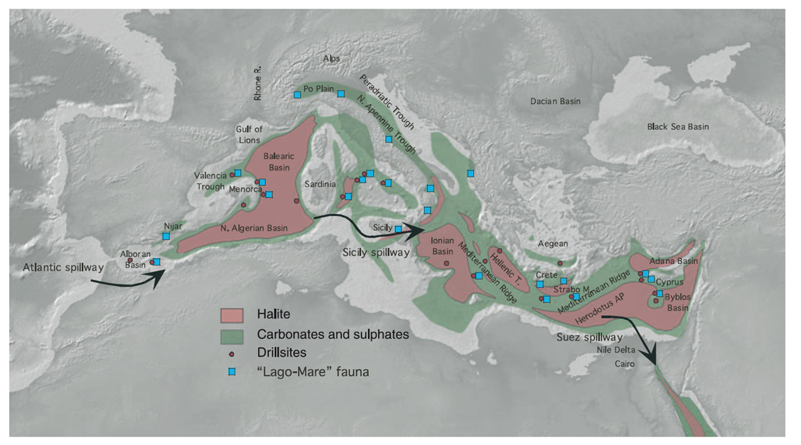
A key unknown that must be mentioned in advance is the depth of the last seaway that allowed the inflow of Atlantic water, the water that replaced the evaporation at the surface of the Mediterranean sea. Hydraulic calculations indicate that a too-shallow seaway (less than ~10 meters deep) would imply a reduction in Atlantic water supply and a drawdown of the Med's level (it would literally evaporate). In contrast, a seaway that was too deep (more than ~30 m) would allow too much mixing between both sides, contradicting the observed salt precipitation. Only intermediate values could allow uninterrupted salt precipitation during the first stage of the Messinian salinity crisis. But, how could the seaway keep in that narrow range of depths when global sea level changes are known to oscillate by several tens of meters? (See fig.3)
1. Cartoon of the detachment and lateral tear propagation
of a dense piece of lithosphere under the Betic
Cordillera. Yellow arrows indicate forces related
to the weight of the slab; white arrows show
vertical motions induced by the tear propagation.
One key obstacle to tackle this question is the lack of good constrains as to which was the last corridor connecting both sides of the Gibraltar Arc. There were several seaways crossing the Betics and the Rif, and all of them closed between 7 and 6 million yrs ago. These corridors are recorded in marine sediments showing paleocurrents and laying today several hundred meters above sea level. But the dating methods have been so far unsuccessful to resolve which was the last one to feed the Med with relatively fresh water.
2. Geological map of the Betics and the Rif (S Spain, N Morocco) combined with tomographic images of the Earth's interior, reaching a 660 km depth. The vertical white arrows show the crustal uplift inferred from the altitude of marine sediments of early Messinian age. 
As for the mechanism responsible for the uplift itself, hints come from isotopic analyses and datations of the volcanism in the Alborán Sea (Duggen, 2003), together with the images obtained via seismic tomography of the Earth's mantle structure. These suggest that the uplift and shrinkage of the seaway may have taken place by a known geological process: due to the detachment of a dense piece of lithosphere (slab break-off). The tomographic images (see figure) use the arrival time of earthquake waves to derive the internal structure of the Earth, and show a lithospheric slab detaching from the Earth's crust underneath the Cordillera Bética. As this body sunk in the upper mantle, it would tear apart (slab tear) and trigger an isostatic rebound of the overlaying Earth's crust. This could explain the uplifted marine sediments in the Betic and Rif cordilleras, providing the uplift rates needed for the closure of the seaways.
3. Sea level changes in the last 8 million years (data from Miller & coauthors, 2005, Science, based on the oxygen isotopic content). The three red dots indicate the initiation of Stages 1 and 2, and the final reflooding of the Mediterranean (ages from Krijgsman et al., 1999). 
But coming back to the essential problem of the mechanisms behind the salinity crisis: Tectonic processes as those discussed above are slow: to produce vertical motions of a few hundred meters they need at least hundreds of thousands of years. But sea level (see figure) changes by tens of meters in periods of a few thousand years. How could then the gateway remain in such a narrow depth range for more than 100,000 years? What kept the seaway neither too deep, nor too shallow in spite of the global sea level variations?
4. Cartoon illustrating the competition between the tectonic uplift of the seaway and its erosion due to the water flow feeding the Mediterranean (Garcia-Castellanos & Villaseñor, 2011).

Our study (Garcia-Castellanos & Villaseñor, 2011) is based on relatively simple hydrodynamic calculations  combined with erosion formulations that had been previously used for landscape modeling and river erosion studies. The results of combining these techniques to simulate the channel connecting the Mediterranean and the Atlantic show that the rate of erosion produced by the incoming waters that compensated the Mediterranean evaporation was similar to the tectonic uplift rate presumed for the Gibraltar Arc, suggesting that uplift and erosion may have been in equilibrium for a long period, keeping the connecting seaway at an approximately constant depth. The results also show that global sea level changes could also have been accommodated by erosion to some extent.  

5. Two simulations as example. Dark lines show an evolution for a slow uplift (red for sea level; black for seaway depth), whereas the light lines are for a fast uplift. In both an equilibrium between erosion and uplift is reached, but the equilibrium decrease of the Mediterranean level required for the slow uplift is smaller than for the rapid uplift. The total amount of inflowing water is in both cases identical, the one that compensated the hydrological déficit of the Med (Garcia-Castellanos & Villaseñor, 2011).
The model also predicts that this competition between uplift and erosion should normally occur out of phase, because the evaporation in the Med needs some hundreds or thousands of years to make the level fall. As a result, a cyclicity in terms of sea level and salt precipitation is predicted that could explain the intriguing cycles observed in the salt deposits all around the coast.
Global sea level fluctuations probably competed with the tectonic uplift by modulating the erosion rates exerted by the overtopping atlantic waters into the Mediterranean (see the supplementary information in the original publication). 
Results from the model:
6. Equilibrium level of the Med as a function of the uplift of the seaway.  
A possible summary (or the simplest one supported by our results) consists of 4 stages (dates from Krijgsman et al., 1999):
  • Stage 0 (before 5.96 million years BP). The Betic-Rifean island arc rose, shrinking the connections between Mediterranean and Atlantic. 
  • Stage 1 (5.96 Ma - ?). A last connection allows the inflow of Atlantic water, and erosion along this enters in competition with uplift, keeping the inflow roughly constant. The Mediterranean level descends some tens or hundreds of meters but it becomes quickly a saturated brine. 
  • Stage 2 (? - 5.33 Ma). Tectonic uplift exceeds seaway erosion and eventually disconnects the Mediterranean from Atlantic water supply. The Mediterranean goes dry, its level drops by 2 km. 
  • Stage 3 (5.33 Ma). The level of the Atlantic exceeds that of the Gibraltar land bridge and triggers a fast refill of the Med.


7. Cartoon of the simplest evolution suggested for the Messinian Salinity Crisis from the modeling results. Stage one corresponds to a cancellation of the outflow from the Med to the Atlantic; Stage 2 is the presumable desiccation starting when the threshold of the seaway becomes above sea level; The Zanclean flood is the refill triggered as the Atlantic waters found a way over the lowest sill of the Gibraltar ARc. 
The mechanism we propose for Stage 1 implies that the last corridor should undergo some hundred meters of erosion, carving a gorge while the surrounding mountains where rising. Finding this gorge nowadays won't be easy, since it has been probably overprinted by the landscape erosion taking place in the 6 million years passed since.
8. Salinidad actual de la superficie de los oceános. La mayor salinidad del Mediterráneo se debe a la mayor evaporación e insolación isolation de sus aguas. Source: World Ocean Atlas 2005
These findings and the extreme geological conditions imposed during th MSC period may help to understand the global change in response to abrupt environmental changes. Since the Mediterranean trapped about 10% of the global ocean salt in at least 100.000 yrs and probably underwent desiccation afterwards, the effects of this should be visible in the biology and climate, perhaps at a global scale. The migration of mammals using the new land bridge formed when the last corridor closed (including African camels that moved to near Valencia, for example) is well documented by paleontologists. But the impact in climate is more elusive from the observational point of view. If climatic data of the multi-million-year time-scale improve, they could allow a better calibration of the multiple parameters of global climate computer models. The desiccation of the Mediterranean offers a unique scenario, a natural laboratory for that calibration, and hence it may help to improve existing climatic models. 


9. Artístic view of the surface and underground events during the early stages of the Mediterranean isolation.
Author: Manuel Mantero; licencia CC-BY-SA 3.0.
Update: The impact of the Messinian Salinity Crisis in exploration and Mediterranean resources will be the focus of a session at the forthcoming AAPG Conference in Barcelona, Spain, April 8-10, 2013 http://www.aapg.org/barcelona2013/

References:
  • Krijgsman, W., Hilgen, F., Raffi, I., Sierro, F., & Wilson, D. (1999). Chronology, causes and progression of the Messinian salinity crisis Nature, 400 (6745), 652-655 DOI: 10.1038/23231
  • Duggen, S., Hoernle, K., van den Bogaard, P., Rüpke, L., & Phipps Morgan, J. (2003). Deep roots of the Messinian salinity crisis Nature, 422 (6932), 602-606 DOI: 10.1038/nature01553
  • Garcia-Castellanos, D., Estrada, F., Jiménez-Munt, I., Gorini, C., Fernàndez, M., Vergés, J., & De Vicente, R. (2009). Catastrophic flood of the Mediterranean after the Messinian salinity crisis Nature, 462 (7274), 778-781 DOI: 10.1038/nature08555
  • Garcia-Castellanos, D., Villaseñor, A. (2011). Messinian salinity crisis regulated by competing tectonics and erosion at the Gibraltar arc Nature, 480 (7377), 359-363 DOI: 10.1038/nature10651
  • Govers, R. (2009). Choking the Mediterranean to dehydration: The Messinian salinity crisis Geology, 37 (2), 167-170 DOI: 10.1130/G25141A.1
  • Garcia-Castellanos D, Villaseñor A (2011). Messinian salinity crisis regulated by competing tectonics and erosion at the Gibraltar arc. Nature, 480 (7377), 359-63 PMID: 22170684

La Crisis Salina del Messiniense (3/3) - Lecciones de la crisis

[capítulo anterior (2/3)]
[Este es un articulo de divulgación, los detalles de la investigación y los enlaces artículos 
científicos recientes puedes encontrarlos aquí].

ResearchBlogging.orgEn las entregas anteriores intenté explicar porqué el intringulis de la desecación del Mediterráneo está en la profundidad del último estrecho que conectó ese mar con el Atlántico. Resumiéndolo: un canal de conexión demasiado somero (menos de ~10 metros de profundidad) implicaría que el Mediterráneo descendería de nivel (literalmente, se evaporaría) debido a la reducción del aporte Atlántico; Un canal de conexión demasiado profundo (más de ~30 m de profundidad) permitiría la mezcla de aguas Atlánticas y Mediterráneas, impidiendo la precipitación de sal. Ambas opciones son poco probables porque se contradicen con la noción de que la crisis salina del Messiniense tuvo una larga etapa inicial de precipitación masiva de sal, más o menos continuada. Además los movimientos isostáticos de  la corteza terrestre en respuesta a la reinundación del  Mediterráneo sugieren que una vez ésta se produce es dificil que se repita un nueva desconexión con el Atlántico (Govers, 2009; Garcia-Castellanos et al., 2009). ¿Cómo pudo entonces el estrecho mantenerse entre ese estrecho margen de profundidades a pesar de las variaciones del nivel del mar que eran también del orden de decenas de metros?

Esquema del desprendimiento y desgarre lateral de un pedazo
de litosfera (de alta densidad) bajo la Cordillera Bética. Las
flechas amarillas indican las fuerzas relacionadas con el peso
de la lámina litosférica; las blancas indican los movimientos 
verticales esperables durante el desgarre.
Una dificultad para ahondar en la cuestión es que no se sabe aún si la última entrada de agua Atlántica al Mediterráneo se produjo a través de la cordillera Bética o de la cordillera Rifeña (que entonces formaban  un arco de islas entre Iberia y África). Hubo varios estrechos que cruzaban ambas cordilleras (Martin et al., 2009). En ellos se encuentran hoy sedimentos marinos de edad Messiniense que prueban aquella conexión, y que están varios cientos de metros por encima del nivel del mar, demostrando que toda la región sufrió un levantamiento. Pero aún no se sabe cuál fue el último estrecho en cerrarse.

Computer animation: How did the Messinian Salinity Crisis start?

We have created a 50 secs. computer animation of what we think the early stages of the Messinian salinity crisis looked like (following the interpretation we publish tomorrow in Nature):
Animator: M. Mantero (license: CC-BY-SA)
EnglishGeography of the Gibraltar Arc during the early stages of the Messinian Salinity Crisis (the period of restricted connection between the Mediterranean and the Altlantic). Our interpretation (scientific paper here) proposes that, at a depth of about 100 km, a piece of dense lithosphere detached from Iberia and sunk in the Earth's mantle. As a result, southern Iberia uplifted and the seaways that connected both seas shrunk progressively. However, this uplift had to compete with the erosion produced by the inflow of Atlantic water into the Med that compensates the excess of evaporation in this sea. This allowed a long-lived inflow stage that explains the enormous amount of salt precipitated in the bottom of the Mediterranean. As the tectonic uplift exceeded the erosion capacity of the inflow, the last seaway emerged and the Med became isolated. The lack of oceanic water supply and the arid climate of the Mediterranean sea both lead to a kilometric drawdown of its level. 
Español: Geografía del Arco de Gibraltar al inicio de la Crisis Salina del Mesiniense (el periodo de incomunicación entre el Mediterráneo y el Océano Atlántico), de acuerdo con la  interpretación que hacemos en la publicación que aparecerá en Nature. En el sur de la Peninsula Ibérica, a unos 100 km de profundidad, una parte de la litosfera se desprendió de la corteza terrestre y debido a su mayor densidad se hundió en el manto terrestre. Como resultado, el sur de Iberia se levantó y los estrechos que comunicaban ambos mares se redujeron progresivamente en profundidad. Este levantamiento tuvo que competir con la erosión producida por la entrada de agua Atlántica (necesaria para alimentar el Mediterráneo, que recibe menos agua de lluvia que la que evapora). Esto explicaría porqué el periodo de entrada de agua Atlántica fue tan prolongado dando lugar a la enorme cantidad de sal que se acumuló en el fondo del Mediterrráneo. Cuando la erosión del fondo del estrecho fue superada finalmente por el levantamiento tectónico, el canal de entrada quedó clausurado por completo, provocando que el clima seco del Mediterráneo hiciera descender rápidamente de su nivel más de un kilómetro.

  • Available under Creative Commons BY-SA license, mentioning the authorship: Concept: D. Garcia-Castellanos, Animator: M. Mantero
  • Free access to the multimedia files here.
    Also available in Commons
  • Related scientific paper [pdf]: Garcia-Castellanos, D., A. Villaseñor, 2011. Messinian salinity crisis regulated by competing tectonics and erosion at the Gibraltar Arc. Nature, 480, 359-363, doi:10.1038/nature10651 
  • More info on the research.

2011-12-07

Recreación del aislamiento del Mediterráneo durante el Messiniense

Con la ayuda de la animación 3D y de Manolo Mantero (animador-texturizador-modelador), estamos recreando en vídeo la geografía del Arco de Gibraltar durante los eventos del Messiniense, hace unos 6 millones de años. Aquí va una imagen preliminar:
English: Geography of the Gibraltar Arc during the early stages of the Messinian Salinity Crisis (the period of restricted connection between the Mediterranean and the Altlantic). Our interpretation proposes that, at a depth of about 100 km, a piece of dense lithosphere detached from Iberia and sunk in the Earth's mantle. As a result, southern Iberia uplifted and the seaways that connected both seas shrunk progressively. However, this uplift had to compete with the erosion produced by the inflow of Atlantic water into the Med that compensates the excess of evaporation in this sea. This allowed a long-lived inflow stage that explains the enormous amount of salt precipitated in the bottom of the Mediterranean. As the tectonic uplift exceeded the erosion capacity of the inflow, the last seaway emerged and the Med became isolated. The lack of oceanic water supply and the arid climate of the Mediterranean sea both lead to a kilometric drawdown of its level. Español: Geografía del Arco de Gibraltar al inicio de la Crisis Salina del Messiniense (el periodo de incomunicación entre el Mediterráneo y el Océano Atlántico), de acuerdo con la  interpretación que hacemos en la publicación que aparecerá en Nature. En el sur de la Peninsula Ibérica, a unos 100 km de profundidad, una parte de la litosfera se desprendió de la corteza terrestre y debido a su mayor densidad se hundió en el manto terrestre. Como resultado, el sur de Iberia se levantó y los estrechos que comunicaban ambos mares se redujeron progresivamente en profundidad. Este levantamiento tuvo que competir con la erosión producida por la entrada de agua Atlántica (necesaria para alimentar el Mediterráneo, que recibe menos agua de lluvia que la que evapora). Esto explicaría porqué el periodo de entrada de agua Atlántica fue tan prolongado dando lugar a la enorme cantidad de sal que se acumuló en el fondo del Mediterrráneo. Cuando la erosión del fondo del estrecho fue superada finalmente por el levantamiento tectónico, el canal de entrada quedó clausurado por completo, provocando que el clima seco del Mediterráneo hiciera descender rápidamente de su nivel más de un kilómetro.

Free access to the multimedia files here.
Also available in Commons
Creative Commons License
This work by Manolo Mantero, Garcia-Castellanos is licensed under a Creative Commons Attribution-ShareAlike 3.0 Unported License.

2011-11-27

Volcanes de lodo

Hace un par de años tuve la oportunidad de unirme a una visita geológica en los Cárpatos y pude ver y tocar los volcanes de lodo de Berca (Rumanía), acompañado de expertos locales. Hoy he encontrado este documental, es algo casero pero es bastante preciso y en español: 
Los volcanes de lodo deben su nombre más a la forma cónica que adoptan, con lodo rebosando por un crater central, que a su relación con los volcanes clásicos, que por otro lado es remota. En los volcanes de lodo, el gas que se produce en bolsas de petróleo u otros hidrocarburos poco profundos empuja hacia la superficie una arcilla con mucho contenido de agua que llega a formar charcas o lagunas donde se ve la emanación de las burbujas. Los gases emanados en superficie suelen ser metano y otros hidrocarburos, anhídrido carbónico y gases sulfurosos. La arcilla suele ser por tanto rica en hidrocarburos sólidos y sales. Dejo también unos videos que tomé en Berca. La primera vez que ves uno de estos, vuelves a ser niño:

Por cierto, los volcanes de lodo siempre me recuerdan a esta sección vertical obtenida a partir de sísmica de reflexión: un corte del subsuelo del Mar de Alborán (Mediterráneo occidental) donde se han descrito volcanes de lodo anteriores y coetáneos a la crisis de salinidad del Mesiniense como responsables de la imagen caótica que se obtiene bajo la discontinuidad erosiva Mesiniense (línea morada). Esta superficie erosiva es una de las principales evidencias de la exposición del fondo marino durante la Crisis (la del Mesiniense):
Perfil de prospección sísmica en el Mar de Alborán, mostrando
presuntos volcanes de lodo a ~2.5 s (unos 2 km) de profundidad. 
¿Qué pudo generar esos volcanes? He leído que la actividad sísmica facilita su formación (por liquefacción del sedimento, creo), y a lo largo de la costa de la región hay sismitas bien documentadas, pero no hay evidencias de actividad importante de fallas. Algo para pensar... 

2011-11-22

Antarctic vertical motions revealed by GPS observations

A new paper in GRL on the vertical motion of Antarctica in response to changes in ice thickness. Partially due to buoyant rebound of the Earth's outer shell (lithosphere) resting on the fluid magmatic mantle?. Abstract follows:

Widespread low rates of Antarctic glacial isostatic adjustment revealed by GPS observations: Bedrock uplift in Antarctica is dominated by a combination of glacial isostatic adjustment (GIA) and elastic response to contemporary mass change. Here, we present spatially extensive GPS observations of Antarctic bedrock uplift, using 52% more stations than previous studies, giving enhanced coverage, and with improved precision. We observe rapid elastic uplift in the northern Antarctic Peninsula. After considering elastic rebound, the GPS data suggests that modeled or empirical GIA uplift signals are often over-estimated, particularly the magnitudes of the signal maxima. Our observation that GIA uplift is misrepresented by modeling (weighted root-mean-squares of observation-model differences: 4.9–5.0 mm/yr) suggests that, apart from a few regions where large ice mass loss is occurring, the spatial pattern of secular ice mass change derived from Gravity Recovery and Climate Experiment (GRACE) data and GIA models may be unreliable, and that several recent secular Antarctic ice mass loss estimates are systematically biased, mainly too high.
Model and data compared
Citation: Thomas, I. D., et al. (2011), Widespread low rates of Antarctic glacial isostatic adjustment revealed by GPS observations,Geophys. Res. Lett.38, L22302, doi:10.1029/2011GL049277.

2011-11-09

The Messinian Salinity Crisis (2/3) - The open scientific question

ResearchBlogging.org [Previous chapter: Salt all over the Med]
[Next chapter: Causal mechanisms for a huge salt pan]
[This is a popular-science article. Details on our research will appear here].


As I wrote in the previous partthe Mediterranean Sea suffers from a very negative budget, also in terms of water: the amount of water delivered by the rivers and by rainfall is not enough to compensate its water losses by evaporation. A surface current entering across the Strait of Gibraltar brings relatively fresh water into the Med. A smaller one flowing underneath flushes out dense, salty water caused by evaporation. 

Did this outflow current not exist, there'd be no mixing with the Atlantic, and all incoming salt would then concentrate in the Mediterranean as it did during the Messinian. In other words, if the outflow is cancelled then the Med would become a giant salt pan; if both inflow and outflow were cancelled, then the Med would just dry up to a level of about 1500-2200 meters below sea level. 

Gravity waves produced by the interplay between the surface
inflow and the submarine outflow across the Strait of Gibraltar.
Date: 06.03.2004 Credit:
NASA Johnson Space Center - Earth Sciences and Image Analysis (NASA-JSC-ES&IA)


By the way, as soon as geologists and oceanographers learned all this, a German architect had the idea of putting it into practice. During the 1920's, Herman Sörgel was pretty good at promoting his project for a huge dam between Algeciras and Tanger (Atlantropa Project) among a large range of wealthy investors. He had the humanitarian aim of bursting economic exchange between Europe and Africa, taking the dubious advantage of a partially desiccated Mediterranean. Anyway, the German rulers at the time had different plans for both Europe and Africa, they were not so much into humanitarism, WWII arrived, and Atlantropa (always look at the bright side) never came to practice. 
Map of the Atlantropa Project (source: Wikimedia Commons)
But going back to science: the cause for the Messinian salinity crisis was (and still is) as controversial as its timing and reach. Was it a major global sea-level fall below the threshold of the seaways? Or a tectonic uplift across the Betic-Rifean corridors? Or a combination? The latter is currently the mainstream opinion among scientists, mostly because the timing of global sea-level drops (related to changes in insolation due to orbital precession of the Earth) does not seem to be timely nor enough in amplitude as to close the marine gateways with the Atlantic. Thus, the uplift of the Gibraltar Arc by tectonic forces must have been the driving mechanism. 

Hydraulic calculations say that the gateway must have been very small (a few tens of meters in depth) during the first stage of the crisis to explain the large salt deposition. A deeper seaway would allow too much mix with the Atlantic and preclude brine formation, whereas a shallower one could not impede the sea level fluctuations (which have a similar amplitude) to repeatedly disconnect and refill the Mediterranean basin. This multiple flooding hypothesis, earlier adopted to explain the large amount of Messinian salt, is now regarded as unlikely, since it would imply repeated up and down tectonic motions for which we don't know of any geological mechanism (Govers, 2009; Garcia-Castellanos and others, 2009).

So, why the combination of rapid, up and down sea level changes, combined with a slow tectonic uplift derived into a long, roughly constant inflow of water through the gateway, instead of repeated drawdown and flooding? 

Before answering that question, we need to dig into the tectonic evolution of the western Mediterranean, which is complex and definitely contentious. Based on polar wander paths and stratigraphy, most geologists agree today that during the Oligocene the western Mediterranean formed as a back-arc basin at the convergence between Africa and Eurasia. Back-arc extension is a process that occurs behind areas where a lithospheric plate subduces under another. In the Mediterranean, the subduction takes place still nowadays, and it accommodates the ongoing approach of several millimeters per year between Africa and Europe. This subduction consists generally of the African plate underthrusting either the European plate or the different Mediterranean oceanic microplates. The Balearic-Betic-Rif mountain chain (aka Gibraltar Arc) would be the western-most end of this back-arc extension. In the case of the Alboran Sea (between Iberia and Morocco) the direction of subduction has not yet been agreed (actually, all possible directions of subduction have been already proposed in scientific papers), but our tomographic studies suggest that it is actually Iberia that may have subduced under Africa and then rolled back until it was left hanging underneath the Betics. 
Tearing and sinking of a lithospheric slab in the Earth's mantle may be occurring underneath the Gibraltar Arc today (after Spakman & Wortel, 2004). This mechanism can produce large vertical motions of the surface that could have closed the seaways during the Messinian. 
Once this lithospheric slab started to roll back towards the west, it detached from the overlying Iberia, tearing apart towards the west. The resulting uplift of the detached areas could have closed the Tethyan marine corridor. For a while the waters of the Atlantic and Mediterranean mixed through the Betic and Rifean corridors (Figure 3), but by ~6 Million years ago evidence of mammal exchange (including camels) between Africa and Iberia indicate that some sort of landbridge existed (Garcés et al., 1998). The sinking of the subducted slab caused uplift of the order of 1 km along the African and Iberian margins, closing the Betic and Rif corridors, isolating the Mediterranean and triggering the Messinian Salinity Crisis. This model is supported by extensive laser 40Ar/39Ar age dating combined with O-Sr-Nd-Pb isotope studies of igneous rocks from the Arc of Gibraltar (Duggen, 2003), and by tomographic imaging from our recent study

Satellite view of the Betics, Rif and Gibraltar Strait.
Camera looking NE. The snowed Spanish Sierra Nevada
is above the center of the image.
Source: NASA, with permission.
Reconstruction of the paleogepgraphy of the Gibraltar Arc prior to the Messinian salinity crisis. Several corridors connected the two ocean domains. Source: Wikimedia Commons
So, there exist some ideas about what deep tectonic mechanisms may have closed the Mediterranean Sea. But the question remains: How does the slow uplift motion produced by such mechanisms reconcile with the survival of a small connection in spite of rapid global sea level fluctuations? I'll detail the explanation we found in the last part of this post.

Links:
Scientific papers:
  • Spakman, W., M.J.R. Wortel, Tomographic view on Western Mediterranean geodynamics, in: W. Cavazza et al. (eds.), The TRANSMED Atlas, The Mediterranean region from crust to mantle: New York, Springer-Verlag, 31–52 (2004).
  • Garcés, M., W. Krijgsman, J. Agustí, Chronology of the late Turolian deposits of the Fortuna basin (SE Spain): implications for the Messinian evolution of the eastern Betics. Earth Planet. Sci. Lett. 163, 69–81 (1998).
  • Krijgsman, W., Hilgen, F., Raffi, I., Sierro, F., & Wilson, D. (1999). Chronology, causes and progression of the Messinian salinity crisis Nature, 400 (6745), 652-655 DOI: 10.1038/23231
  • Duggen, S., Hoernle, K., van den Bogaard, P., Rüpke, L., & Phipps Morgan, J. (2003). Deep roots of the Messinian salinity crisis Nature, 422 (6932), 602-606 DOI: 10.1038/nature01553
  • Garcia-Castellanos, D., Estrada, F., Jiménez-Munt, I., Gorini, C., Fernàndez, M., Vergés, J., & De Vicente, R. (2009). Catastrophic flood of the Mediterranean after the Messinian salinity crisis Nature, 462 (7274), 778-781 DOI: 10.1038/nature08555
  • Govers, R. (2009). Choking the Mediterranean to dehydration: The Messinian salinity crisis Geology, 37 (2), 167-170 DOI: 10.1130/G25141A.1

2011-10-28

The Messinian Salinity Crisis (1/3) - 1-km salt layer over most of the Mediterranean

[part 2/3 of this post] [part 3/3] [Spanish version]
[This is a science-diffusion article, an introduction to the MSC. Details on our research will appear here upon publication]


Pliny the Elder begun his Historia Naturalis (the oldest known encyclopedia) describing the geography known to the Romans. His account inevitably starts at the narrow entrance to their Mare Nostrum (the Mediterranean Sea), echoing local myths on the origin of the two sharp mountains flanking the Strait of Gibraltar:
"(...) the inhabitants believe that the two mountains were dug through by Hercules, upon which the sea, which was before excluded, gained admission, and so changed the face of nature."
Today we can only speculate on how was Pliny's account originated, but amazingly enough, science is giving us strong evidence that the Mediterranean was once indeed largely desiccated and that it was later refilled in a catastrophic event, just as those native Iberian peoples thought.


Pliny knew very little about the formation of the Earth: he simply lacked the scientific knowledge accumulated ever since. However, he understood that the Earth is not static but it changes as a result of dynamic processes. And he did know the widespread salt outcrops present along most of the Mediterranean coast: The Romans profusely used the gypsum salt crystals as window glasses, for example. Did they make a link between that salt and a past desiccation of the Mediterranean Sea?

Geoscientists inspecting the Realmonte mine in Sicily,
where Messinian salt is commercialized. 
In 1867, paleontologist Karl Mayer-Eymar realized that those gypsum outcrops formed in a similar geological age, and named that period Messinian after the impressive salt mines near the Sicilian town of Messina. In 1877, Carl Ochsenius published an influential work on the formation of such salt giants, these large deposits of salt recognized in many regions. The period of Mediterranean-wide salt deposition was recognized in 1954 as a dramatic environmental crisis, and accordingly became known as the Messinian Salinity Crisis, after the italian geologist Raimondo Selli. Only in the last decades has been the crisis properly dated as 5.3 to 6 million years old, around the time when the first hominins walked in Africa.

The whole mountain in this picture is made out of gypsum
salt crystals deposited during the earliest Messinian Salinity Crisis.
The unsettling house too. The blocks are fallen due to the steep
valley later excavated by the Aguas river. Near Sorbas (S Spain).
Photo: Garcia-Castellanos. 

During the Messinian times, as today, the Mediterranean was also a region undergoing deficit. I'm not talking about economics here, but about a hydrological deficit: the amount of water delivered by the rivers and by rainfall to the Med is not enough to compensate its water losses by evaporation. Thanks to the connection at the Strait of Gibraltar, this deficit is compensated by a net inflow of 70,000 m3/s of Atlantic water, a flow equivalent to about 40 times the Niagara Falls. The Atlantic is thus constantly refilling the Mediterranean net evaporation. This current is well known and feared by sailors because it easily brings your ship to a speed of several meters per second in one of the busiest crossroads in the world. Less known is the outflow current underneath, bringing deep, dense, saline water from the Med to the Atlantic. Both were widely used during WWII, by submarines aiming at crossing the strait silently (great film, Das Boot).

Present inflow and outflow from the Atlantic across the Gibraltar
Strait. The outgoing current is denser and runs underneath the inflow. 
Both were used by the submarines during World War II to sneak
in and out of the Med silently (Prenhall/Pearson).
Ochsenius theory of barriers
or thresholds (1877) to
explain the presence
of large salt deposits in the
geological record. 
Important: note that to increase the salinity of the Mediterranean it only takes a reduction of the outflow, whereas in order to make it dry, it also requires cancelling the inflow. For this reason, the presence of salt of Messinian age does NOT imply that the Mediterranean went dry. Artificial salt pans, for example, evaporate sea water keeping the brine at a constant level, maintained by further inflow of seawater. In 1849, italian chemist J. Usiglio experimented with this process and described in detail how, although the sea salt contains ten times more halite than gypsum, it is gypsum that precipitates first due to its lesser solubility. This could explain the abundance of gypsum onshore the Mediterranean, in contrast with the relative scarcity of onshore halite.
Present water salinity at the surface of the ocean, showing a
saltier Mediterranean caused by the higher evaporation 
and isolation of its waters. Source: World Ocean Atlas 2005

But what happened then offshore? If the salts were related to a pan-Mediterranean event, salt should also have accumulated in the deeper parts of the sea. Only in the 1960s, studies of the reflection of seismic waves (echoes of vibrations sent from a boat) started to show ubiquitous evidence of a disruption of the sediment layers, a few hundred meters below the seafloor. It was named the 'M reflector', and extended laterally up to approximately the 1500 m depth contour of the present sea, suggesting a widespread erosion event. Besides, the M reflector seemed to have formed simultaneously with the accumulation of a thick layer of a peculiar rock visible in the seismic reflections from the deepest parts of the Mediterranean basin. Today we know that this layer trapped about 10% of the oceans' salt during the Messinian times.

In the 70's, 3000-m-deep drillings carried out on board the Glomar Challenger proved the presence of salt deposits offshore Mallorca, demonstrating that the classical onshore outcrops had an equivalent in the open sea. It also found anhydrites and pebbles, interpreting that the Mediterranean consisted of a series of brackish lakes, possible remnants of a desiccated Med. But these were just weak circumstantial evidence, and both could be (and were indeed) strongly argued.
Distribution of Messinian salts in the Mediterranean 
(Ryan, 2008)

All the research published was supporting the existence of a great evaporitic basin affecting both the shallow marine basins at the margins of the Mediterranean and the deeper inner parts of the sea. But still this does not imply a desiccation or a large drawdown of the Med, as discussed above. 


Section across the Nile in Aswan (Egypt) by Chumakov (1967), 
based on wells. It shows a valley excavated by the 
river during the MSC, now filled with later sediments.
The main evidence really supporting a desiccation and a large level fall of the Mediterranean had arrived actually somewhat earlier, back in the late 1950s. The building of the Aswan Dam (1,200 km upstream from Alexandria) was disturbed by the discovery of a deep narrow gorge excavated in granite, hundreds of metres below sea level (Chumakov, 1967). This gorge has been since filled by loose sediments that hindered the construction of the dam. It is now known that the gorge follows and deepens downstream the Nile, reaching around 2000 m deep below Cairo. The Rhone, Ebro and Po rivers also have similar gorges buried below their present deltas, filled with post-Messinian sediment. In contrast with other canyons formed today in the Atlantic or the Pacific (linked to turbidity currents originated underwater at the continental shelf), the Messinian ones along the Mediterranean coast look like drowned river valleys (Loget et al., 2006, Urgeles et al., 2010).


Valley excavated during the Messinian salinity crisis at the
mouth of the Ebro River, as derived from recent seismic
reflection images. Scientific paper here
Today, the development of the MSC is still a matter of debate, and the occurrence of a large drop of the Mediterranean level is not yet fully agreed. What are the arguments in favor and against this possible Mediterranean desiccation? And what were the processes responsible for the crisis? In an upcoming post I will detail on this, and in a 3rd one I will focus on the outcomes of our own research that will soon appear in Nature. [update: link; pdf here]

[Go to the next chapter]


References:

  • Pliny's Historia Naturalis full text.
  • More science diffusion on the MSC in this article and in David Bressan's blog.
  • The scientific paper will be linked here upon publication.
  • Loget, N., Van Den Driessche, J. On the origin of the Strait of Gibraltar. Sedim. Geol. 188–189, 341–356 (2006).
  • Chumakov, I. S. (1973), Pliocene and Pleistocene deposits of the Nile valley in Nubia and upper Egypt, Initial Rep. Deep Sea Drill. Proj., 13, 1242-1243.
  • Ryan, W. B. F., Decoding the Mediterranean salinity crisis. Sedimentology 56, 95-136 (2008). doi: 10.1111/j.1365-3091.2008.01031.x

2011-10-25

ground displacements of the Sendai / Tohoku-Oki earthquake (Japan)

Impressive video of the ground motions during Japan's earthquake. Horizontal motion in blue (left panel) and vertical component in red (right). The movie shows the displacements due to the M9.0 and M7.9 earthquakes in Japan on March 11, 2011 (data, no model!). Each dot/arrow represents a continuous high precision GPS station of which more than 1200 are distributed throughout Japan in a network called GEONET. According to the author (Grapenthin, Alaska Univ.) this is an absolutely unique instrumentation density found nowhere else on the world.

You can distinguish body and surface waves, dynamic slip, and static displacements. Further details and higher resolution video for download at: http://gps.alaska.edu/ronni/sendai2011.html

Visualization: R. Grapenthin, Geophysical Institute, Univ. Alaska Fairbanks.
Data: preliminary GPS positioning solutions provided by ARIA/HPL/Caltech (ftp://sideshow.jpl.nasa.gov/pub/usrs/ARIA). All original GEONET RINEX data were provided to Caltech by the Geospatial Information Authority (GSI) of Japan.


Original scientific paper:
Grapenthin, Ronni; Freymueller, Jeffrey T.
The dynamics of a seismic wave field: Animation and analysis of kinematic GPS data recorded during the 2011 Tohoku-oki earthquake, Japan (from 0530 - 0630 UTC)
Geophys. Res. Lett., Vol. 38, No. 18, L18308
http://dx.doi.org/10.1029/2011GL048405
22 September 2011

2011-10-23

La Crisis Salina del Messiniense (2/3) - El progreso de la crisis

[English version here]
[Capítulo anterior: El Mediterráneo se evaporó]
[Este es un articulo de divulgación, los detalles de la investigación puedes encontrarlos aquí]

Cuando Plinio describió el mundo conocido por los romanos en su Historia Naturalis, comenzó, lógicamente, por el Estrecho de Gibraltar. Y citó una leyenda local según la cual a los dos peñones que flanquean la entrada al Mare Nostrum...
"[...] los llaman las Columnas de Hércules porque creen que él las separó con su espada, permitiendo la entrada del mar, que antes estaba excluída"

(Vídeo para Inspiraciencia presentando la Historia Natural de Plinio, 2016)

No conocemos el orígen de esta leyenda, pero hoy existen indicios sólidos de que el fin de la desecación del Mediterráneo consistió en una rápida inundación desencadenada al desbordar las aguas Atlánticas el Estrecho de Gibraltar (ver este post anterior). Y hemos visto evidencias convincentes de que, antes de eso, el Mediterráneo estuvo efectivamente aislado y probablemente desecado ¿Cual fue la causa de ese aislamiento? ¿Qué originó la Crisis Salina del Mesiniense?

[Source: Prenhall/Pearson]
La desmesurada concentración de sal durante ese periodo es un escenario excepcional, incluso para un geólogo. Para entenderla hay que dejar un momento el campo de la sedimentología y curiosear en la climatología y la tectónica de placas. Todavía hoy, el clima de la cuenca mediterránea es relativamente seco. El agua que aportan los ríos y la lluvia al mar no compensa la evaporación en su superficie. Debido a este déficit hídrico, la salinidad del Mediterráneo es ligeramente mayor (un 0.2 %) que la del océano global y si la diferencia no es mayor es porque hay una constante mezcla con el Atlántico a través del Estrecho de Gibraltar. Una corriente de agua Atlántica entra por la parte más superficial, mientras que otra más salada y densa sale en profundidad. Ambas corrientes fueron muy utilizadas por los submarinos en la Segunda Guerra Mundial para entrar y salir silenciosamente del Mediterráneo (véase por ejemplo el memorable film Das Boot) y todavía se encuentran restos de submarinos bombardeados en la región. La interacción entre ambas es responsable de las ondas de gravedad mostradas en la segunda imagen del capítulo anterior. Para mantener el nivel del Mediterráneo, la entrada de agua es un 3% mayor que la corriente de salida que circula en profundidad.  Los marinos que atraviesan el estrecho conocen bien la fuerza de esa corriente, como también la conocían en tiempos de Plinio. Tal vez los habitantes del sur de Iberia encontraron con su leyenda una relación entre esa corriente y la masiva presencia de sales a lo largo de la costa mediterránea. O tal vez el acierto de esta visión tan dinámica de la Tierra fuera sólo una casualidad.
La entrada neta de agua en el Mediterráneo es en promedio 70.000 m3/s, que equivale a unas 40 veces el caudal de las cataratas del Niágara. Si hoy se construyera una barrera en el estrecho que impidiera esta entrada de agua, el nivel del Mediterráneo descendería casi un metro cada año. Por inverosímil que parezca, esta idea ya se le ocurrió al ingeniero alemán Herman Sörgel en 1929, que planeó la construcción de un inmenso dique en Gibraltar con la idea de unir Europa y Africa secando el Mar Mediterráneo: el Proyecto Atlántropa. Es una de las más disparatadas distopías que conozco y afortunadamente no prosperó, pero ilustra bien lo que pudo suceder durante el Mesiniense: que el nivel del mar global quedara por debajo del umbral del estrecho y al quedar el Mediterráneo literalmente incomunicado, se evaporase.
Vista satelital de las Béticas, el Rif, y el Estrecho de Gibraltar.
La cámara mira al NE, las cumbres de Sierra Nevada
están en el centro superior.
Reconstrucción de la geografía del Arco de Gibraltar antes del inicio de la crisis Mesiniense. Había varias conexiones entre los dos mares. Fuente: Smith609 @ Wikimedia Commons
Hay que mencionar que esa conexión Atlántico-Mediterráneo no estaba en el Estrecho de Gibraltar como en la actualidad, sino en varios estrechos que atravesaban lo que se conoce como el Arco de Gibraltar (la actual cordillera del Rif y de las Béticas, que entonces era un arco de islas entre Iberia y África). Hay aún dudas sobre si la última entrada de agua Atlántica se produjo a través de la cordillera Bética o de la cordillera Rifeña (en Marruecos). En ambas zonas se encuentran sedimentos Mesinienses que prueban aquella conexión marina, y en ambas esos sedimentos están muchos cientos de metros por encima del nivel del mar, lo que sugiere que el aislamiento del Mediterráneo pudiera haberse producido por un levantamiento de ambas regiones. El análisis del volcanismo del Mar de Alborán (Duggen, 2003) y las imágenes obtenidas de la estructura interna del manto terrestre indican que este levantamiento pudo producirse de forma parecida a otras zonas del planeta: un pedazo de litosfera se habría desprendido de la corteza terrestre, hundiéndose en el manto fluido debido a su mayor densidad.

Dos ciclos de yeso cristalino Mesiniense con una intercalación de roca margosas,
cerca de Sorbas (Almería, España). Fuente: Wikimedia Commons
Sin embargo, el análisis de isótopos de Estroncio contenidos en los sedimentos ha confirmado que durante una larga fase inicial de la crisis salina, antes de la desecación, el Mediterráneo recibía agua del Atlántico. Esto por un lado es muy interesante, porque sugiere que el Mediterráneo actuó como una enorme salina y en apenas 100.000 años el agua que entraba contendría suficiente sal para explicar el enorme volumen depositado en el fondo. Pero para ello, el estrecho de comunicación no podía ser ni demasiado pequeño (para no impedir el flujo de entrada que compensa la evaporación) ni demasiado profundo (para no permitir la salida de agua hacia el Atlántico y no diluir así la salmuera). La profundidad del estrecho tendría que ser, según cálculos hidráulicos, de pocas decenas de metros. Y esto entra en conflicto con la noción de que el aislamiento resultó de una competición entre el nivel del mar y alguna forma de levantamiento tectónico de los estrechos: estos procesos funcionan en escalas de tiempo muy distintas, de unos pocos miles de años en el caso del nivel del mar y de millones de años en el caso de la tectónica. ¿Cómo pudo entonces mantenerse el estrecho tan somero durante un periodo de tiempo tan largo? 


En la última parte de este post contaré la explicación que proponemos (que aparecerá publicada próximamente en la revista Nature). Habrá que indagar en los procesos que pudieron producir esta secuencia de sucesos registrados en los sedimentos del fondo del Mediterráneo. A cambio, tal vez podremos entender cómo responde nuestro planeta ante situaciones tan extremas como la que atravesó el Mediterráneo durante la era Mesiniense. (Continuará...)