[This is a science-diffusion article, an introduction to the MSC. Details on our research will appear here upon publication]
"(...) the inhabitants believe that the two mountains were dug through by Hercules, upon which the sea, which was before excluded, gained admission, and so changed the face of nature."Today we can only speculate on how was Pliny's account originated, but amazingly enough, science is giving us strong evidence that the Mediterranean was once indeed largely desiccated and that it was later refilled in a catastrophic event, just as those native Iberian peoples thought.
Pliny knew very little about the formation of the Earth: he simply lacked the scientific knowledge accumulated ever since. However, he understood that the Earth is not static but it changes as a result of dynamic processes. And he did know the widespread salt outcrops present along most of the Mediterranean coast: The Romans profusely used the gypsum salt crystals as window glasses, for example. Did they make a link between that salt and a past desiccation of the Mediterranean Sea?
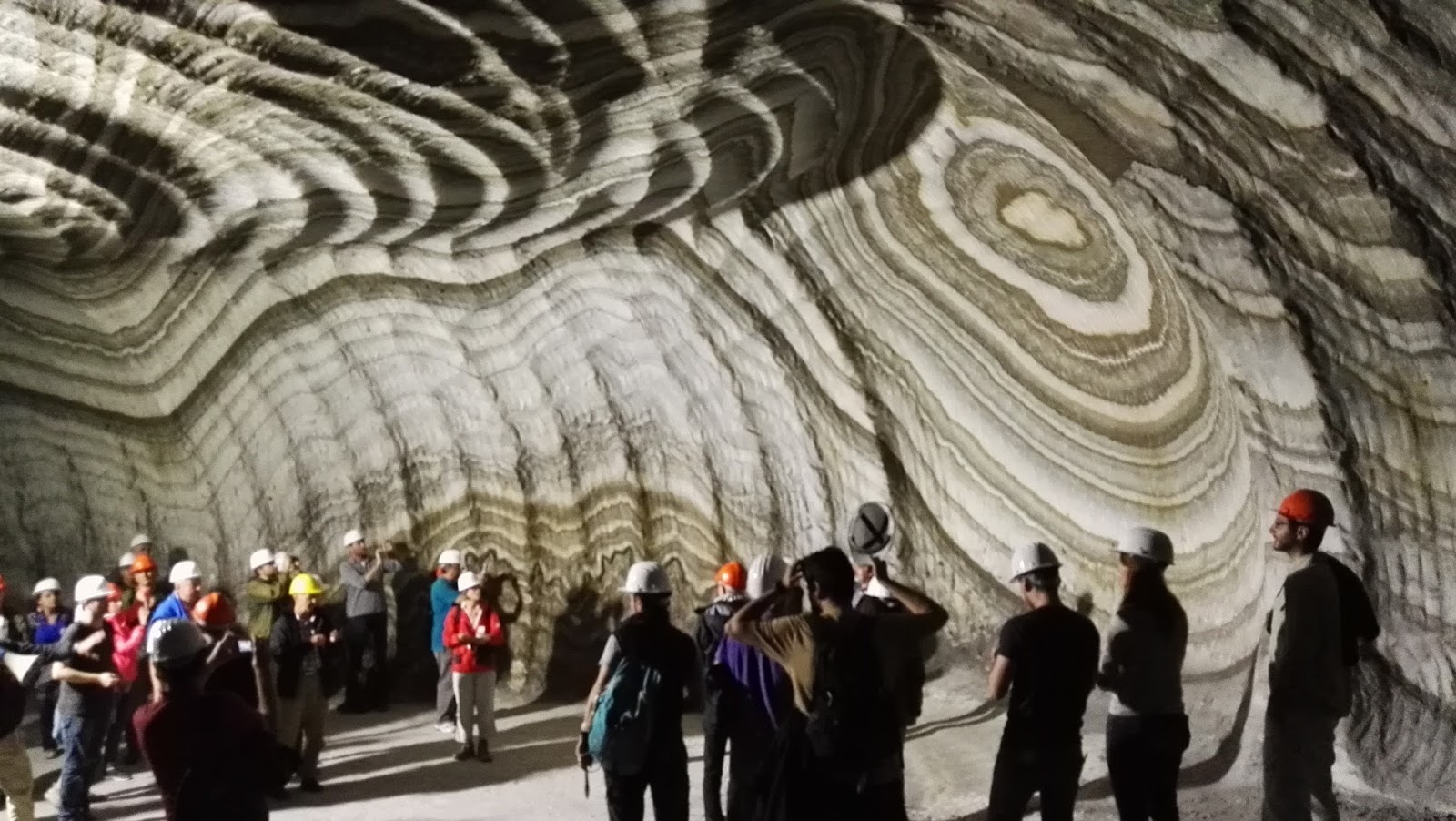 |
| Geoscientists inspecting the Realmonte mine in Sicily, where Messinian salt is commercialized. |
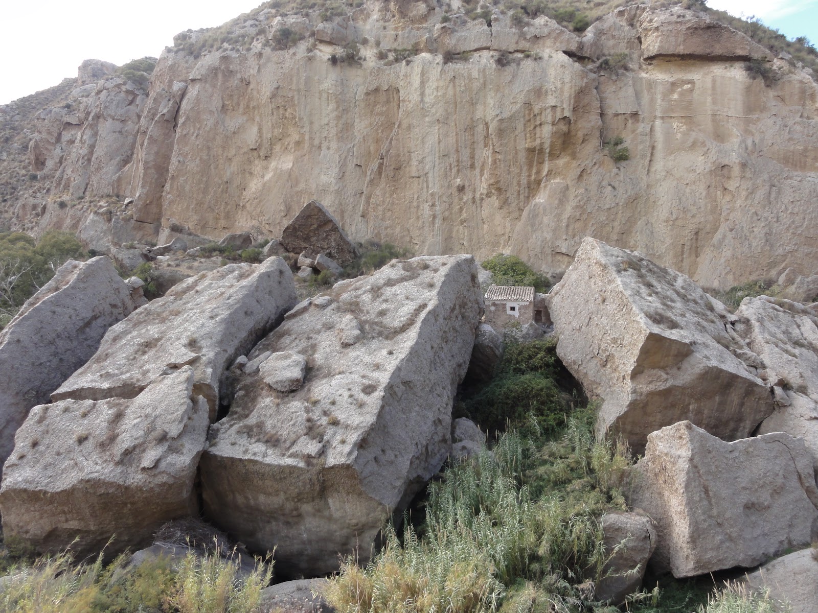 |
The whole mountain in this picture is made out of gypsum
salt crystals deposited during the earliest Messinian Salinity Crisis.
The unsettling house too. The blocks are fallen due to the steep
valley later excavated by the Aguas river. Near Sorbas (S Spain).
Photo: Garcia-Castellanos.
|
During the Messinian times, as today, the Mediterranean was also a region undergoing deficit. I'm not talking about economics here, but about a hydrological deficit: the amount of water delivered by the rivers and by rainfall to the Med is not enough to compensate its water losses by evaporation. Thanks to the connection at the Strait of Gibraltar, this deficit is compensated by a net inflow of 70,000 m3/s of Atlantic water, a flow equivalent to about 40 times the Niagara Falls. The Atlantic is thus constantly refilling the Mediterranean net evaporation. This current is well known and feared by sailors because it easily brings your ship to a speed of several meters per second in one of the busiest crossroads in the world. Less known is the outflow current underneath, bringing deep, dense, saline water from the Med to the Atlantic. Both were widely used during WWII, by submarines aiming at crossing the strait silently (great film, Das Boot).
 |
| Present inflow and outflow from the Atlantic across the Gibraltar Strait. The outgoing current is denser and runs underneath the inflow. Both were used by the submarines during World War II to sneak in and out of the Med silently (Prenhall/Pearson). |
 |
| Ochsenius theory of barriers or thresholds (1877) to explain the presence of large salt deposits in the geological record. |
 |
Present water salinity at the surface of the ocean, showing a
saltier Mediterranean caused by the higher evaporation
|
But what happened then offshore? If the salts were related to a pan-Mediterranean event, salt should also have accumulated in the deeper parts of the sea. Only in the 1960s, studies of the reflection of seismic waves (echoes of vibrations sent from a boat) started to show ubiquitous evidence of a disruption of the sediment layers, a few hundred meters below the seafloor. It was named the 'M reflector', and extended laterally up to approximately the 1500 m depth contour of the present sea, suggesting a widespread erosion event. Besides, the M reflector seemed to have formed simultaneously with the accumulation of a thick layer of a peculiar rock visible in the seismic reflections from the deepest parts of the Mediterranean basin. Today we know that this layer trapped about 10% of the oceans' salt during the Messinian times.
In the 70's, 3000-m-deep drillings carried out on board the Glomar Challenger proved the presence of salt deposits offshore Mallorca, demonstrating that the classical onshore outcrops had an equivalent in the open sea. It also found anhydrites and pebbles, interpreting that the Mediterranean consisted of a series of brackish lakes, possible remnants of a desiccated Med. But these were just weak circumstantial evidence, and both could be (and were indeed) strongly argued.
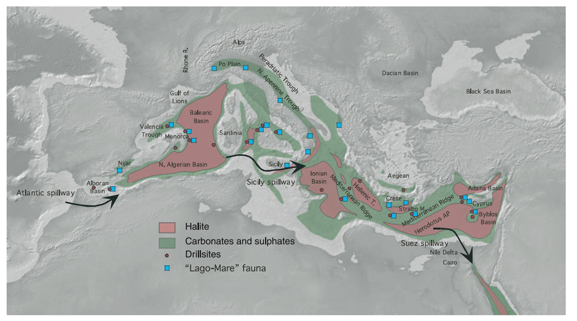 |
Distribution of Messinian salts in the Mediterranean
(Ryan, 2008)
|
All the research published was supporting the existence of a great evaporitic basin affecting both the shallow marine basins at the margins of the Mediterranean and the deeper inner parts of the sea. But still this does not imply a desiccation or a large drawdown of the Med, as discussed above.
 |
Section across the Nile in Aswan (Egypt) by Chumakov (1967),
based on wells. It shows a valley excavated by the
river during the MSC, now filled with later sediments.
|
 |
| Valley excavated during the Messinian salinity crisis at the mouth of the Ebro River, as derived from recent seismic reflection images. Scientific paper here. |
[Go to the next chapter]
References:
- Pliny's Historia Naturalis full text.
- More science diffusion on the MSC in this article and in David Bressan's blog.
- The scientific paper will be linked here upon publication.
- Loget, N., Van Den Driessche, J. On the origin of the Strait of Gibraltar. Sedim. Geol. 188–189, 341–356 (2006).
- Chumakov, I. S. (1973), Pliocene and Pleistocene deposits of the Nile valley in Nubia and upper Egypt, Initial Rep. Deep Sea Drill. Proj., 13, 1242-1243.
- Ryan, W. B. F., Decoding the Mediterranean salinity crisis. Sedimentology 56, 95-136 (2008). doi: 10.1111/j.1365-3091.2008.01031.x
About the water balance. If the outflow of salty water that happens in deep waters is stopped, then also the inflow must stop or being greatly reduced, because it would be compensated only by evaporation. Right? If it is like that, and you measure the water deficit due to evaporation and the thickness of the evaporitic layer, you should be able to estimate how long the messinian crisis lasted. Right? Well, not so straight forward because evaporation depends on temperatures...are there good enough climate reconstructions that can be used for such a purpose?
ReplyDeleteHi Umberto. Yes, in fact it's a simple budget, because the water deficit is well known (the present one). If you divide the volume of water that you need to evaporate (to precipitate the salt accumulated in the Med) by the water deficit you get (if we'd trust my memory) about 60,000 yr. But there are indications of a wetter climate during the early messinian, so it might be double than that.
ReplyDeleteThe water balance of the Messinian can only be reconstructed by proxy. These study are actually in progress. THe fact is that we don't know the supply of the rivers. Many studies report the presence of large rivers in north africa, which would be able to change the Med budget. Indeed there are also studies that estimates the duration of the salt deposition in a few thousand years. But salt deposition was only a part of the crisis. Probably the acme, but probably very short in time. The rest was much longer, as it supposed to be around 700 Kyr. Of course it was not a continuous evaporitic basin during all this time.
ReplyDeleteCheers. I agree about the Med's water budget, recent example of new tributaries: [Bowman, 2012 - Petroleum Geoscience]. As for the sedimentation gap (supposedly representing the Med level lowering) it may be as short as a few kyr's (last news i have: Cosentino et al., 2013 - Geology), but all these datations are very hypothetical, they rely on the identification of gypsum and lago-mare cyclicity as precessional.
Delete