2012-09-10

Watch the Lithosphere moving up and down

The lithosphere, the uppermost resistent layer of the Earth, rests on the fluid mantle underneath and moves up (or down) in response to weight removed from its surface (or placed on it), such as ice capes, large lakes, mountain ranges, volcanos...  
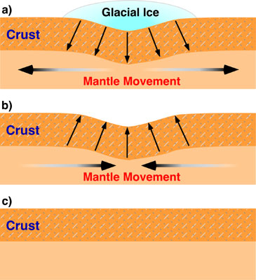
Isostatic sinking (subsidence) and
rebound (uplift) occurring when an
ice sheet forms by climate cooling
and when it is removed by climate warming.
The downwarping (isostatic subsidence)
produced by the ice accumulation in a) is
fully recovered in this process (b and c). 
My first steps into geoscience dealt with this concept called isostasy, which looked somewhat simple to a recent graduate in Physics as I was back then, since it simply applies the Archimedes Principle to the Earth's lithosphere. But this idea was just emerging in the late 19th century. And still, G.K. Gilbert was there to get it and to apply it to one of its most conspicuous scenariosLake Bonneville. 

Lake Bonneville was an enormous closed lake (meaning it had no outlet) encompassing the western half of Utah during the Pleistocene. The Great Salt Lake is a small remnant. It would be among the few largest, deepest, and highest lakes today. When its level raised to 1500 m above sea level at the end of the last glaciation, 15,000 years ago, its waters found an exit through the Red Rock pass and the lake was suddenly drained. It produced one of the largest floods ever recorded: the Bonneville Flood (see this previous post). But there was another consequence to the flood: When the lake water was released, the lithosphere under the lake moved upwards to readjust its isostatic equilibrium with the viscous mantle that underlies the Earth's crust. 

Now, do you believe this story?

2012-09-02

La otra gran crisis Mediterránea (la del Messiniense)

Si hoy se construyera una barrera en el estrecho de Gibraltar, el Mediterráneo descendería de nivel casi un metro cada año, debido a que recibe menos agua de los ríos y la lluvia que la que evapora en su superficie. Por inverosímil que parezca, un arquitecto alemán estuvo cerca de poner en práctica esta idea en 1929: Herman Sörgel planeó la construcción de un inmenso dique en Gibraltar con el dudoso objetivo filantrópico de unir Europa y África secando el Mar Mediterráneo: se trata del Proyecto Atlántropa.
Flujo de agua superficial (flechas blancas) y profundo (flechas oscuras)
en el Mediterráneo durante 11 meses de 2005-2006. Se puede distinguir la 
doble corriente en el Estrecho de Gibraltar.