 |
| Present display of the meteorite at the AMNH museum in NY. My photo. |
Last week I visited again the rock with the most fascinating story on Earth:
Tomanowos, meaning the visitor from the sky in the extinct Clackamas language, also known as the Willamette meteorite.
 |
| Supernovas spread throughout space the iron produced in heavy stars. This ejected iron ends up in particle nebulas that eventually form new stars and protoplanets. [Image: NASA] |
When European Americans found it near the Willamette River (Portland, OR) more than a century ago, Tomanowos inevitably went through one of the most hilarious and silly geological stories that I know of, surely driven by the fatal attraction that a rare rock like this exerts on humans. But before going into that let me tell a few things about its origins.
Tomanowos is a rare 15 ton meteorite made of iron and nickel (Fe 91%, Ni 7.6%). As in other metal meteorites, these Fe and Ni atoms formed at the core of stars that shattered the space with the products of nuclear fusion when ending their lives in supernovae explosions. These elements ended up in the nebula that clumped together as protoplanets in our Solar System, and Tomanowos was part of the core of one of these protoplanets, where the heavier metals accumulate.
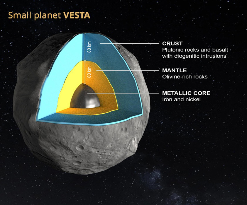 |
Vesta, a surviving protoplanet of the
early Solar System. Due to their large
size, protoplanets develop a differenciated density distribution with heavier elements like iron concentrated in the core. Tomanowos is an ejected piece of a protoplanet core like this. [EPFL/Jamani Caillet, Harold Clenet] |
Over the following decades, the ice flow slowly transported Tomanowos southwards, towards a glacier lobe that was at the time blocking the Fork River in Montana (USA). The glacial tongue piled ice across the river valley forming a 600-m-high ice-dam that impounded the enormous Lake Missoula. Following the ice flow, Tomanowos happened to reach the dam on the precise year when it collapsed, releasing one of the largest floods ever documented: the #MissoulaFloods that shaped the Scablands in Washington. This process is known as glacial outburst flooding and it still happens every few years in the Perito Moreno glaciar, for example. Except that the water discharge during the Missoula Floods reached the equivalent to a few thousand Niagara Falls. The research of the Missoula floods by Bretz and Pardee in the early 20th century led to one of the most significant paradigm shifts in recent geoscience: the recognition that catastrophic events can significantly contribute to the evolution of landscape.
 |
| Map of the Missoula Floods path, showing Lake Missoula (blue), the ice cap where Tomanowos landed (north of the lake outlet), and the inundated areas of Washington and Oregon (grey). Source: Washington Univ. |
Trapped in ice and rafted down by the flood, Tomanowos crossed Idaho, Washington and Oregon along the overflown Columbia River at speeds sometimes faster than 20 meters per second. While floating up on the flood waters near today's Portland, the ice case broke apart and the meteorite sunk in the flooding waters. Hundreds of other ice-rafted erratics (rocks that do not match the local geology, nor could be transported by rivers or glaciers) have been found along the Columbia River. All are souvenirs from the Missoula floods, but none as rare as Tomanowos.
As the flood ceased, the sunk meteorite became exposed to the atmosphere. Over thousands of years, rain mixed with the iron sulfide inclusions producing sulfuric acid that gradually dissolved the iron of the exposed side of the rock:

A few thousand years after the flood, the Clackamas arrived to Oregon and named the meteorite as the Visitor of the Sky, a heaven's representative that unified earth, water & sky. Apparently they knew that nickel rocks come from heaven. Were they intrigued by the absence of a crater at the Meteorite site? In any case, the name reminds us that pre-scientific cultures were not idiotic, or not more than us today anyway.
To confirm this latter hypothesis, in 1902 a colonist named Ellis Hughes decided to secretly move the iron rock to his own land and then claim property. Millennia of peaceful rest in the Willamette valley had to come to an end. But because moving a 15-ton rock a distance of 1,200 m without being noticed is not easy, not even in Oregon, Hughes and his son labored for three back-breaking months in secrecy:
To confirm this latter hypothesis, in 1902 a colonist named Ellis Hughes decided to secretly move the iron rock to his own land and then claim property. Millennia of peaceful rest in the Willamette valley had to come to an end. But because moving a 15-ton rock a distance of 1,200 m without being noticed is not easy, not even in Oregon, Hughes and his son labored for three back-breaking months in secrecy:
 |
| As D. J. Preston hilariously explains, after finally succeeding with the moving, Hughes built a shack around the meteorite, announced he had found it on his property and started charging twenty-five cents admission to view the heavenly visitor. |
It was during this transport that the rock sadly underwent severe mutilations.
Unimpressed by this deployment of idiocy, Hughes' neighbor fabricated a lawsuit contending that the meteorite had, in fact, landed on HIS property. And to buttress his case he showed investigators a huge crater on his land. The case was dismissed when a third neighbor reported a great deal of blasting only the week before the trial.
Unimpressed by this deployment of idiocy, Hughes' neighbor fabricated a lawsuit contending that the meteorite had, in fact, landed on HIS property. And to buttress his case he showed investigators a huge crater on his land. The case was dismissed when a third neighbor reported a great deal of blasting only the week before the trial.
Ironically, the legitimate owner of the original land of the iron rock turned out to be the Oregon Iron and Steel Company, so far unaware of the meteorite but promptly hiring a twenty-four-hour guard who sat on top of it with a loaded gun while the case was being appealed. They won the case in 1905, selling Tomanowos to the AMNH museum in New York a year later.
 |
| Tomanowos in the early 1900s, before being transported to the AMNH. |
Today, amazingly enough, the AMNH exhibition does not even mention the Missoula Floods as a key part of Tomanowos' story, in spite of the wide scientific consensus. Same as the meteorite, the Clackamas were also reallocated to a reservation. Their descendants do keep the right to visit Tomanowos in NY and talk to the visitor who brought the Sky, the Water, and the Earth together.


